Add a data to the map with the Isogeo plugin
To add a data directly to the map canvas, let's take a look to the options available in the "Add" column.
Here come the different use cases:
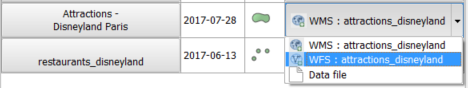
- The dataset can be added through different options. User choose its preferred option in the drop-down list.
- The dataset can be added through only one way. The column "Add" is a button.

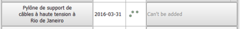
- The dataset can't be added: file is not reachable and any correct webservice is linked.
Criteria
File data
Metadata field Resource location of Identification tab has to contain the absolute path to the datafile.
This path must be reachable:
- by the system user who launched QGIS (read);
- from the machine if the data is located on a local network.
Cache
To improve performances, the plugin embed a minimalist cache system storing the unreachable paths. To empty the cache, click on the dedicated button in settings tab.
Supported formats
Vector
- DXF
- DGN
- Esri FileGDB
- Esri shapefile
- MapInfo tab
Raster
- ECW
- Esri ascii grid
- Geotiff
- Intergraph gdb
- JPEG
- PNG
- XYZ
PostGIS
A PostGIS table can be added when:
- the connection to the database has been already set in QGIS
- the option "Save username and password" has been choosen
- the metadata has been created by the Isogeo Scan
Geographic webservices
Plugin supports webservices layers which have been associated to metadata.
Supported services
- Web Feature Service (WFS)
- Web Map Service (WMS)
- Web Map Tile Service (WMTS)
Important note Be careful, if service layer title, description or style name contains any special characters, it won't be possible to display it. It's a QGIS issue and related to a bad encoding management in PyQGIS.